
Walk a Wall Street by Address
A useful Wall street directory is a record trail, not a list of people. Start with a complete street address and keep the house number, direction, suffix, unit, postal city, ZIP code, municipality, and county in separate notes. The county property search accepts a street name or part of a street name, so it can locate the situs, the official property location. That result may identify an owner of record, but it does not establish that the owner lives there. A dated directory or a lawfully available voter result can add a different kind of connection.
- Use the Monmouth property search with Wall selected as the township and the full address or street fragment. Save the block and lot, owner field, situs, mailing address, assessment, and access date when displayed.
- Open the same property in the Monmouth County GIS Map Viewer. Identify the parcel, turn on useful layers, and note adjacent parcel IDs without treating the map as a survey.
- Use the New Jersey voter registration check only as a time-specific registration and district clue. An empty result can reflect exact-spelling, update, inactive-status, or protected-data issues.
- Take the parcel key or owner name to the Monmouth County Clerk’s OPRS index. Compare the newest recorded instrument with the map and assessor data before working back through earlier deeds.
- For a past household, compare the address and locality wording with county directories, census material, newspapers, or the library’s historical collections. Keep each source year beside the name it supplies.
The order matters. A current tax record may confirm a parcel relationship, while a deed shows a recorded transfer and a directory supplies a dated listing. The Wall street directory becomes stronger when those roles remain separate instead of being blended into a claim about present occupancy.
Wall Street Directory Property Search
The Wall Tax Assessor maintains current ownership records for more than 11,200 parcels. Its tax-list books are an in-person route for owner of record, mailing address, property location, assessed value, tax maps, and sales from the past year. Online, the county’s OPRS property interface offers address, block-and-lot, map, and owner-name modes. Use the address path for a street search, then capture the block and lot before shifting to the deed index.
| Wall property-search field | Input type | What the researched interface supports | Careful reading |
|---|---|---|---|
| Township Name | Select | Required for address, block-and-lot, and name modes | Select Wall rather than relying on a postal city. |
| Address | Text | Street name or a partial street name is accepted | It searches the property location, not a person roster. |
| Owner Name | Text | Current owner or part of a name | An owner field is not a current-resident finding. |
| Block, Lot, Qualifier | Text | Block-and-lot route, including qualified parcels | These are the parcel keys that bridge map and deed work. |
| Map location | Interactive | Zoom, right-click, and a radius choice | Use it for spatial discovery, then verify the record fields. |
The Monmouth/Wall property-search interface shows the address, owner, block-and-lot, and map routes used in a Wall street directory search.
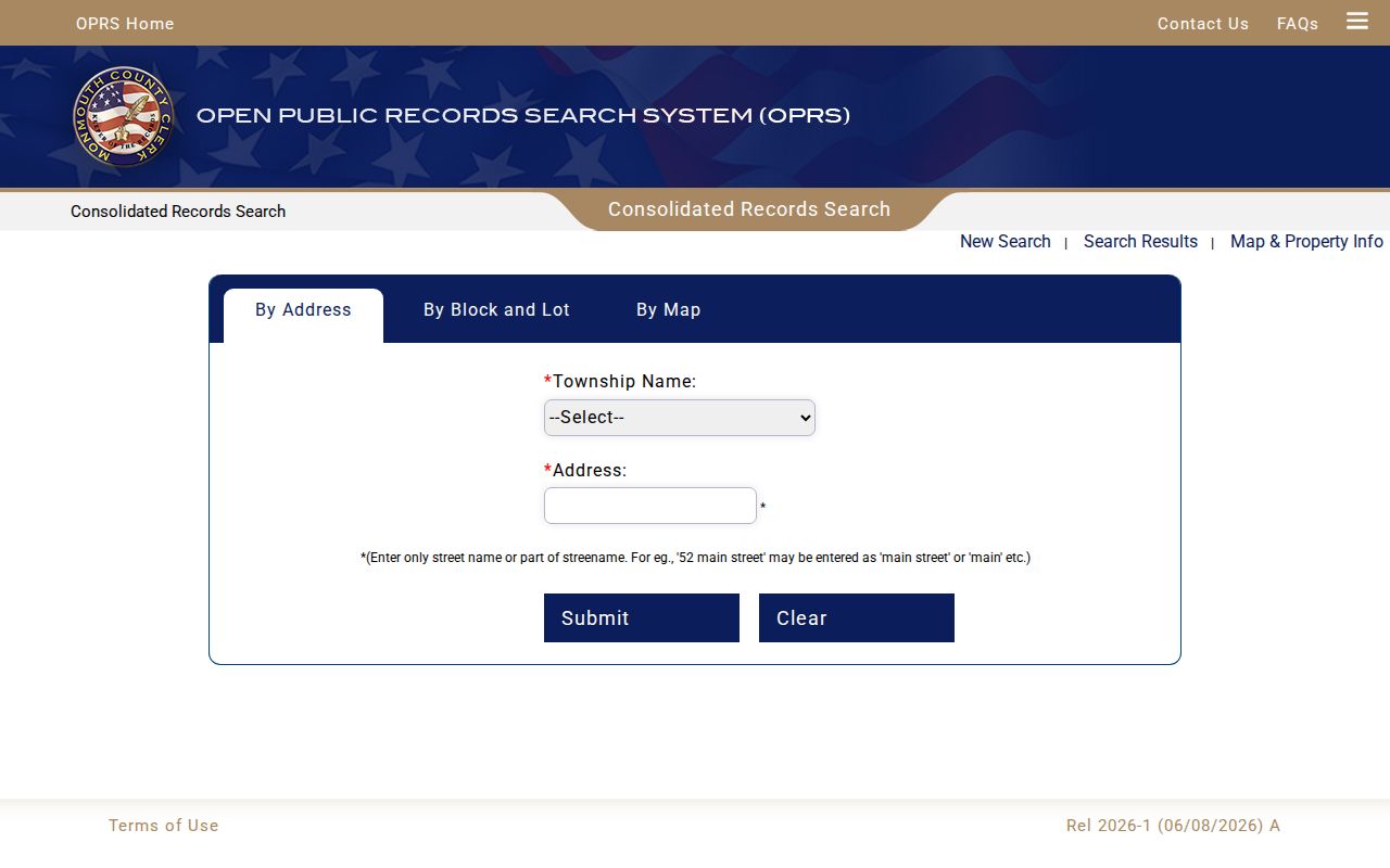
The screen is a starting point for current parcel evidence. The online portal is not a title certificate or a full address-history archive, so a street search should retain the access date and move to the appropriate county counter when older confirmation is needed.
Wall Street Parcel Map Clues
The county GIS viewer turns an address into a parcel polygon and lets a Wall street search compare nearby block-and-lot identifiers. Its controls include pan, zoom, identify or click, layer visibility, and popup navigation. Record the map scale, visible layer name, parcel ID or block and lot, and the access date. Owner or assessment fields should be copied only when the live layer displays them.
The Wall mapping page also points to the township’s informational zone map, while NJGIN’s parcel resources provide a statewide fallback by address, county, municipality, block, and lot. NJGIN warns that parcel geometry is not survey-grade, and county source layers can differ. Use a GIS shape to orient a record search, not to settle a boundary question.
Neighboring polygons can also help when an older deed describes a tract, road, or subdivision instead of the modern house number. They do not identify every person along the road. A visible parcel relationship and a person’s connection to that parcel are separate findings.
Wall Street Tax Roll Route
For a wider Wall street directory pass, the county tax-roll search has a street-oriented address mode. It supports Street Name, Township, and Year. The same public system also has owner, block-and-lot, and aggregate modes. Its owner route adds an owner name, township, year, and tax-exempt selector; its parcel route includes block, lot, qualifier, exempt options, township, and year.
The Monmouth tax-roll search did not expose a ZIP field. That omission is useful information: a ZIP code is not the right key for a county tax-roll search. Use a street name with Wall and a year, then narrow a result with the block and lot or property search rather than assuming every address sharing a postal code belongs to the same township record set.
Tax lists distinguish a mailing address from the property location. Either field can be meaningful, but neither alone proves who occupies a Wall address today. This is the central practical limit of an address-first street directory.
Wall Street Deed Chain
After the parcel is identified, use OPRS to inspect the recorded interest attached to it. The Clerk’s interface supports an instrument number, document type with municipality and date range, block and lot, or a party-name route. Name queries permit the percent wildcard, and document-type windows cannot exceed 90 days. A recording date is the date the Clerk recorded the instrument. Book and page are the index’s unique identifiers.
Online search notices list deeds from January 1, 1970 forward, mortgages from January 1, 1976, IRS liens and related releases from January 1, 2010, and other published records from October 1, 1996. Earlier work moves to the County Clerk’s in-person title-search counter, county microfilm, Archives or State Archives finding aids, or FamilySearch county deed books. OPRS describes its online results as informational rather than accurate for title searches.
The Monmouth County OPRS deed-index search provides the grantor, grantee, instrument, and date-range paths that support a Wall street directory deed trail.
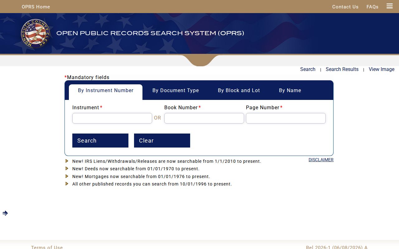
When an image is available, record the instrument number, book, page, recording date, document type, municipality, grantor, grantee, block or lot if shown, and search context. A deed documents a recorded transfer, not a promise that either named party lived at the Wall address.
Wall Street Directory Record Coverage
Different Wall records answer different address questions. The table keeps each source’s access route and evidence type visible, including the in-person and request alternatives when a public online interface is incomplete. A street name can connect the sources, but the parcel key is usually the most dependable bridge among tax, GIS, and recorded-land material.
| Wall address record | Address key | What it can support | Access route |
|---|---|---|---|
| Wall tax-list books | Situs, block/lot, owner, mailing | Owner of record and the mailing-versus-situs distinction | Assessor office and OPRS/MOD-IV route |
| County GIS | Parcel geometry and block/lot | Adjacent parcels and visible attributes | County viewer, with NJGIN fallback |
| County deeds | Grantor/grantee, legal description, block/lot | Recorded property-interest chain | OPRS online notice from 1970; earlier counter, microfilm, or archive routes |
| County tax roll | Street, owner, block/lot, year | Owner and tax-category entries for a selected year | OPRS tax-board modes |
| Voter material | Address, municipality, district | Registration or district clue only | State search or lawful county-list procedure |
| Building and land-use records | Address, permit, legal description | Applicant, owner, or contractor evidence if released | No public search interface located; request defined existing records through Wall OPRA |
| Directories and newspapers | Printed street, locality, address | Historical person or business association | Library, MCHA, microfilm, and digitized collections |
For a defined deed-copy request, the Clerk accepts in-person, letter, or email requests and asks for the owner name, property address, lot and block, and book/page or instrument number. The office is at 33 Mechanic Street in Freehold; its official contact information should be used instead of a solicitation for a deed copy.
Wall Street Locality Aliases
A Wall street directory search should not discard an older locality label. Official township material names Algers Mill, Allaire, Allenwood, Atlantic Avenue Circle, Baileys Corner, Blansingburg, Brielle Circle, Como Road Circle, Earle N.A.D., Glendola, Hurley’s Corner Circle, Lake Como, New Bedford, Old Mill, Osbornes Mills, Osborn Island, Remsen Mills, Shark River, Treasure, Wall, and West Belmar. In a historical record, those terms can be part of the address trail rather than a mistake.
Allaire needs special care because it can be a person, place, or road reference. When an older house number fails, try the street fragment, old locality label, block and lot, deed legal description, historic map, and adjacent owners. No comprehensive municipal renumbering log or modern address-change table was located in the official research, so an unresolved number should be taken to the assessor or tax-map custodian instead of guessed.
- Parcel
- A property unit tracked by the county or township with identifiers such as block and lot.
- Situs address
- The property’s physical location, distinct from the owner’s mailing address.
- Plat
- A recorded map used to show lots, streets, or subdivisions when a deed description needs map context.
- Criss-cross directory
- An address-organized directory used to compare a street or locality with a dated name listing.
Note: Preserve the original locality and postal wording in a historical citation, then compare it with today’s township, parcel, and postal fields.
Wall Street Record Update Dates
A Wall street directory search should preserve the date and version of every dynamic source. Monmouth's custom OPRS search displayed Rel 2026-1, dated June 8, 2026, and NJGIN identified an August 2026 parcel-data update that included Monmouth. A map layer can change when a parcel attribute is refreshed even though the underlying deed has not changed. Save the access date, portal release or layer date when visible, and avoid treating a current screen as a timeless record.
For a contested address detail, compare the assessor's access date, the deed recording date, and the date printed on a directory or newspaper. Those dates describe different events and should not be collapsed into one occupancy claim.
Wall Street Directory Through Time
Historic directory material can test a past connection after the parcel and deed work are complete. The Monmouth County Library Historical Room holds directories, scrapbooks, local books, and newspapers, and its Wall branch at 2700 Allaire Road offers public computers, scanning, Wi-Fi, printing, and copies. Headquarters in Manalapan keeps the secured, non-circulating Historical Room for deeper collection use. A printed directory is a time slice, not proof of a present address.
County runs include the 1875 J.H. Lant directory, Boyd’s volumes for 1898-99, 1900-01, and 1904-05, the 1914 Farm and Business Directory, and New Jersey Historical Society reels through 1920-21. Pair an exact directory year and locality heading with census, tax-ratable, newspaper, or deed evidence. The historical collection details belong with the Wall city directory resources, where the regional holdings and reading method are treated in depth.
Newspapers can fill a gap around a street name. MCHA’s obituary indexes begin in July 1830 for the Monmouth Inquirer and Monmouth Democrat, while the Red Bank Register run spans June 1878 through December 1988. Their value is dated context. A notice, directory, or census entry should never be recast as a current resident record.
Wall Street Directory Limits
Wall address records have real privacy and scope boundaries. State and local material can shield home addresses and unpublished phone numbers of covered people under Daniel’s Law, and blank names in parcel layers can be a lawful redaction rather than a data error. The New Jersey Office of Information Privacy reported more than 10,000 covered people in its April 2025 redaction milestone. Do not try to reconstruct a protected name or address from other records.
Voter information has its own statutory field and signature protections. Motor-vehicle information, unlisted phone numbers, Social Security numbers, signatures, and other protected details are not ordinary public address fields. A court party name, old directory listing, deed, license, or owner field also cannot be used as a current-residence claim without a source that actually supports that conclusion.